
HURRICANE ANDREW TIMELINE – AFTER LANDFALL + Tropics today
- Bryan Norcross

- Aug 24, 2022
- 4 min read
Thirty years ago this morning, at 8:00 AM on Monday, August 24, 1992, the center of Hurricane Andrew was just moving into the Gulf of Mexico. Winds at the Miami airport were still gusting to about 80 mph, but the worst was over. The incredible, unimaginable hurricane was finally letting up on Dade County.

People in destroyed neighborhoods ventured out of their homes into a world they didn’t recognize. And were forced into a situation more terrifying than the storm. For the rest of that week, the nights were the worst. There was no power, no water, looters roamed the neighborhoods, and gunfire echoed through the desolation. It was hell on earth in South Dade after the storm.

Crazy things had happened that night. Cars were flipped over in their garage. Or piled on top of one another. Palm trees were pierced. All just from the wind.
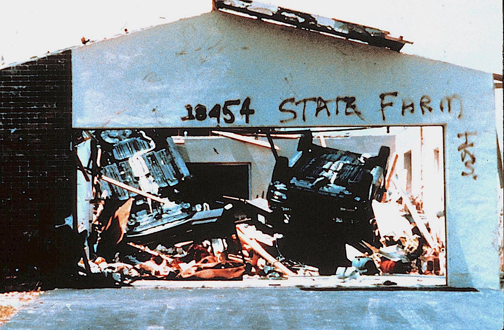


Roads were blocked so getting in and of the destruction zone was hard or impossible. People got lost walking around the block because all the trees and road signs were knocked over or blow away.
But that Monday morning, most people just felt relief that they had survived the all-out attack they experienced in the hours before sunrise.
At the wounded National Hurricane Center, they were focusing on the Gulf coast. The computers were overheating, and many of the data feeds were disrupted when the satellite dishes were destroyed or blew away. A number of the employees lost their homes in the storm, and many more had significant damage that was going to require extensive repairs. But they had enough data and determination to keep going. It was magnificent – a tour de force.
Hurricane Hunters that Monday afternoon found that Andrew had weakened a little as it crossed the Florida peninsula, but not much. The expectation at that point was that Andrew would power over the northern Gulf coast as a powerful Category 4 hurricane.

By late afternoon and evening, the focus had narrowed to the Mississippi and southeastern Louisiana coasts. Hurricane Warnings were issued, with Hurricane Watches extended west to the Louisiana/Texas line and east along the Alabama coast.
Just after midnight, I finally left the TV station and drove home. I decided to take I-95 out of downtown Miami for a short span because I knew many of the surface streets were blocked with debris. I’ll never forget looking south from the elevated section of the highway and seeing only black. And imagining what people were going through in South Dade in that first night since life had been upended.
I only made it home because I had a 4-wheel-drive truck at the time. I was able to navigate over curbs and lawns to get around poles, signs, and trees that blocked the way. My headlights were the only illumination on my four-mile drive to my home in Coconut Grove just south of downtown.
The power was out, but I felt lucky, and a little guilty. I slept in my bed that night and thought about the hundreds of thousands who were sleeping wherever they could find a dry corner in their ruined home to set up camp.
Meanwhile, Andrew was headed toward the northern Gulf coast.
AND IN 2022...
Two areas to watch in the tropical Atlantic on this 30th anniversary of Hurricane Andrew
The tropical Atlantic is a complicated place this hurricane season. The tropical disturbance that we’ve been following across the central Atlantic is no longer a factor. It never had much of a chance anyway. Now there are two other areas of interest.
The first one is just southeast of the southern Caribbean islands. The disturbance has flare up over the past couple days. Computer forecast models show it moving into the Caribbean where the atmospheric conditions are predicted to be conducive for a tropical system to eventually develop.
It’s not unheard of for a disturbance to develop from this location, but it’s not common. This disturbance is quite far south. The weather pattern has to be perfect for systems in the deep tropics to pull north. And second, if it can lift north, it will be moving through the eastern Caribbean, a notorious rough road for developing systems due to its proximity to South America.
The computer forecast models acknowledge these realities and keep the system disorganized for the next few days. The National Hurricane Center is giving it a low chance of development through this weekend.
After that, it’s an open question. If it can survive as a defined disturbance, the environmental conditions might be more conducive for development next week in the western Caribbean.
The NHC is also making note of the slight possibility of a system developing in the eastern Atlantic. A disturbance is forecast to move off Africa in a day or so. If the forecast weather pattern is right, the system might develop after a few days. It’s too far in advance speculate much beyond that, however. The National Hurricane Center is also giving this possible disturbance a low chance of developing.
All this is a sign that the tropics are slowly stirring, if not waking up. Exactly why we have gone since early July without a named system is not obvious. Clearly there is excessive dry air across the tropical Atlantic. But the reason for that is unclear, though there are lots of ideas. We’ll see how the analysis shakes out.
So it’s time to pay attention in case something suddenly spins up, although it’s more likely that next week will be the starting point.
コメント